|
The Indian Analyst
|
|
North Indian Inscriptions |
INSCRIPTIONS OF THE CHANDELLAS OF JEJAKABHUKTI in Mahuāli-grāma in the Kōlavā-pattalā, donated to him previously by the chief queen Vālhaṇadēvī and queen Chāndala, respectively, with the consent of the king. Lines 29-33 mention the conditions of the grant, which are almost the same as to be found in the other Chandēlla charters. This portion is followed by eight benedictory and imprecatory verses (ll. 34-40) ; and a prose-passage showing the king’s consent. Then the inscription has two verses recording the names of the writer and the engraver, as seen above ; and wishing good to all, the grant ends with a symbol between two vertical strokes engraved three times.[1]
Of the geographical names occurring in the inscription, Kālañjara (l. 4) has often been seen to be identical with the hill-fort in the Bāndā District, and Pāṭaliputra (ll. 16 and 25) is the modern Patnā in Bihār. Parēyi-grāma, where the king was staying while making the donations (l. 14), cannot be identified for want of details, as also the names of the villages mentioned in the grant. Dr. Sircar located Nandāvaṇa-pattalā which is also mentioned in the Ichchhāvar grant of Paramardin,[2] in the Bāndā District and Navaraṭha-pattalā (the Navarāshṭra vishaya of the Charkhārī grant[3] in its vicinity on the Yamunā ; and Ērachha-pattalā may be taken identical with the modern Erich, about 96 kms. from Mahōbā, as suggested by Hiralal.4 Sircar also suggested that Vāndiuri, Tintiri and Pipalahā (ll. 21 and 27) may possibly be the same as the modern Bāndā, Tēonthar and Piplōn-durga. Kōlavā, after which pattalā was so known, has so far remained unidentified. It appears to be represented by the modern village of the same name (also spelt as Kōlvā), situated almost 40 kms. due north-east of Vidishā. This suggestion receives strength from the identification of both the villages which are stated to have been then included in it, namely, Mahuālī (l. 28) and Vasauhā (l. 20), the first of which may have been the same as Mahaulī, about 20 kms. straight north of Kōlvā, and the second as Vasaī, about 10 kms. south-east of it. A consideration of the places mentioned in the inscription makes it evident that Madanavarman’s kingdom, which included parts of the modern Hamīrpur, Bāndā and Vidishā Districts and probably extended up to the Yamunā, in the north, also included parts of the former Rewā State (now a district of the same name) to the north of the Kaimūr range as is also known from the discovery of a hoard of his silver coins in the Teōṅthar tehsīl of this district.[5]
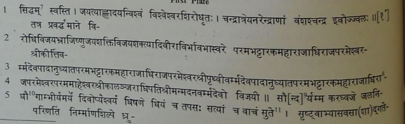
TETX[6]
_____________________ | ||||||||||||||||||||||||||||||||||||||||||||||||||||||||||||||||||||||||||||||||||||
| > |
|
>
|