|
The Indian Analyst
|
|
South Indian Inscriptions |
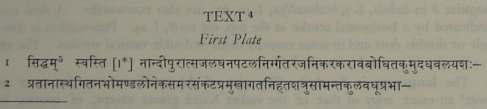
INSCRIPTIONS OF THE EARLY GURJARAS connection with the Kairā grants, the doubling of th after an anusvāra in pamtthāh, 1.12 and of k before r in yajñādikkriy-, 11.17-18. The plates were issued from Nāndīpura by Dadda who had obtained the pañchamahāśabda. As in the Kairā plates, he calls himself Praśāntarāga, the son of Vītarāga, in his sign-manual. He is, therefore, identical with Dadda II of the Early Gurjara dynasty. Unlike the Kairā plates, the present inscription does not contain any eulogy of his two predecessors─his grandfather Dadda I and his father Jayabhata IVītarāga. The Plates record the grant of a field in the village Suvarnārapalli which was situated in the vishaya of Sangamakhētaka, requiring for its seed grains one pitaka of paddy by the measure prevalent in that vishaya, together with the usual rights and exemptions. The donee was the Brāhmana Sūrya of the Bharadvāja gōtra and the Vājasanēya Mādhyandina śākhā, who had previously emigrated from Daśapura and was then residing at the village Kshīrasara. The grant was made for the purpose of providing for the five great sacrifices and other rites. The donated field was bounded on the east by the junction with the boundary of the village Kshīrasara, on the north by the junction with the boundary of the village Kukkutavallikā, on the west by an agrahāra field, a banyan tree and a talāikā (tank?) and on the south by the way leading to the village Suvarnārapalli and the junction with (the boundary of) Atavīpātaka. The plates were written by Rēva, the head of the Department of Peace and War. The grant is dated both in words and in numerical symbols on the fifteenth tithi of the bright fortnight of Vaiśākha in the year 392. This date must, of course, be referred to the Kalachuri era. According to the epoch of 248-249 A.C., it would correspond, for the expired year 392, to the 20th April 642 A.C.1 It does not admit of verification.
As for the localities mentioned in the present inscription, Nāndīpura which is clearly identical with Nāndīpurī of the Kairā grants, has already been identified with Nāndōd in the Broach District. Daśapura is Mandasōr in Western Malwā. Sangamakhētaka, the headquarters of the vishaya named after it, is clearly modern Sankhēdā where the plates were discovered. As Dr. Bühler says, ‘Samgamakhētaka means etymologically ‘the village at the confluence (of two rivers), and the Unchh and the Or2 join near Sankhēdā. The vishaya or province of Samgamakhētaka probably included the Sankhēdā Prānt of the Gaikwād’s possessions, as well as the neighbouring portion of Rēvākānthā Agency, still called Sankhēdā Mēvās’. Of the villages mentioned in the present grant, only two can be identified. Kukkutavallikā3 is apparently identical with Kukad, about 8 miles westsouth-west of Sankhēdā. Kshīrasara may be Khariākuā, about a mile to the east of Kukad.
TEXT4
1If the year is applied as current, the date would correspond to the 30th April 641 A.C. |
||||||||||||||||||||||||||||||||||||||||||||||||||||||||||||||||||||||||||||||||||||||||||||||||||||||||||||||||||||||||||||||||||||||||||
|
|